
Key Notes
- Pietro Miotti says 48 AI agents reviewed images from roughly 1,200 square kilometers of NASA lidar coverage and flagged a possible Maya hilltop complex.
- He revised and submitted the report himself, then published an October 21 INAH reply stating that no archaeological site was registered at the reported location.
- The search used archived airborne measurements from 2013, and the landforms’ age and archaeological interpretation still await expert field verification.
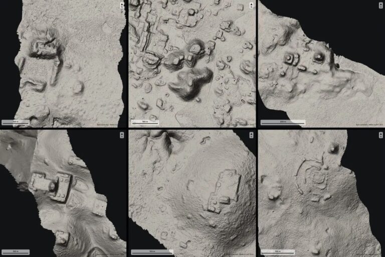
Pietro Miotti says a search involving 48 AI agents has flagged a possible Maya site beneath Mexico’s jungle. The agents reviewed images derived from roughly 1,200 square kilometers of NASA lidar coverage, identifying a hilltop complex that he could not match to existing archaeological records.
Miotti, who says he is not an archaeologist, recounted the experiment in a diary covering October 18–21. His published evidence includes terrain images, point-cloud profiles and a reply attributed to Mexico’s National Institute of Anthropology and History, or INAH. The site’s archaeological interpretation still awaits field verification.
From an overnight search to an official reply
According to Miotti, the agents followed a written guide to inspect lidar images for features such as platforms, plazas and pyramids. They checked candidate locations against literature and archives. He describes the remaining hilltop as having a leveled plaza, a possible pyramid, a raised courtyard and a hollow that could have stored water.
The agents also examined raw lidar points to distinguish ground surfaces from vegetation. The published plots label gaps in ground returns at some mound tops. Miotti says he corrected parts of the report, translated it into Spanish with AI assistance and sent it to INAH on October 20. The process was directed and reviewed by him, including the decision to contact the institute.
The letter he published is dated October 21. It states that a check of the institute’s geographic information system identified no registered archaeological site at the reported location. That is a narrower finding than confirmation of a new Maya settlement: the response concerns the register, while the age and function of the landforms remain to be established.
Older airborne data can reveal a different landscape
The images are based on NASA’s G-LiHT lidar data from 2013. G-LiHT is an airborne instrument system, so this was a new analysis of archived measurements collected from an aircraft. NASA describes it as a system for mapping ecosystem composition and structure, combining lidar, imaging spectroscopy and thermal measurements.
Lidar measures distances with laser pulses. Returns reaching the ground through gaps in foliage can be separated from vegetation returns to help construct a terrain model. That makes it possible to examine shapes obscured in an ordinary overhead photograph. NASA’s public data description includes classified ground returns and three-dimensional coordinates among the available measurements.
Those models can expose a platform or mound for closer inspection, but interpreting its origin requires more evidence. Dating a structure or identifying a temple involves questions that a geometric outline alone cannot settle. The useful contribution of automation here is screening a large archive and organizing leads for specialists to investigate.
A candidate for archaeologists to assess
Reusing environmental lidar for archaeology already has a substantial record. A 2024 study in Antiquity identified the major Maya urban area named Valeriana in Campeche, Mexico, through analysis of existing lidar data. Its authors described monumental precincts, dense settlement and extensive landscape modification. That work provides a precedent for overlooked survey data yielding archaeological insights, without validating Miotti’s separate candidate.
The appeal of the AI workflow is the possibility of bringing more eyes to such archives. Our coverage of a planet candidate found with Claude Code explored a similar path: an interested outsider uses AI to analyze public scientific data, then seeks expert assessment of the result.
Miotti says he offered to assist an INAH-led field check and is waiting for the local institute to decide whether to send a team. No expedition is confirmed in his account. For now, the outcome is a documented lead and a registry response, with the archaeological work needed to establish what is on the hill still ahead.
Disclaimer: AIstify is an independent media brand owned and operated by NuvexMedia LLC, publishing news, research, and insights on artificial intelligence, emerging technologies, automation, and related industries. NuvexMedia LLC invests in and collaborates with companies across the AI, technology, software, and digital innovation sectors. These relationships do not influence AIstify’s editorial coverage, and the publication maintains full editorial independence to provide accurate, timely, and objective information. © 2026 NuvexMedia LLC. All rights reserved. This content is for informational purposes only and should not be considered legal, tax, investment, financial, or other professional advice.